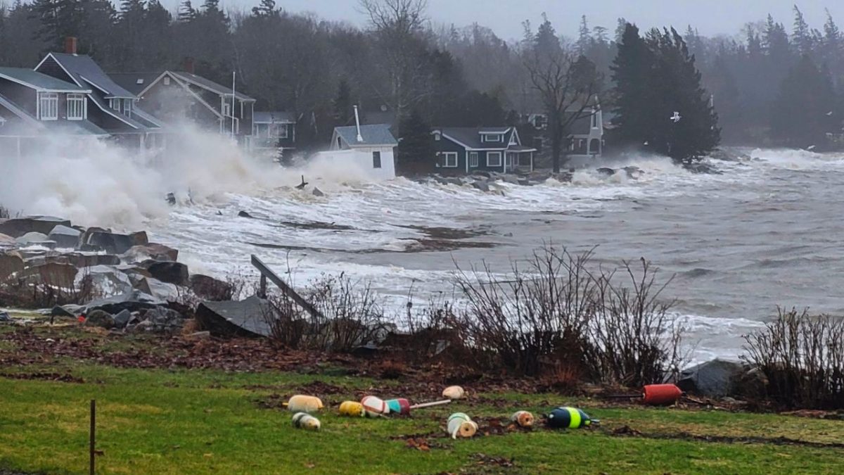
On Saturday, Jan. 13, a historic storm battered the Maine coast, ringing in the new year with the crushing reality — an increase in extreme weather events may be on the horizon for East Coast residents.
Maine is no stranger to strange weather — rainfall and precipitation are abundant in the United States’ northernmost state. However, this showcase of extreme weather differs from many storms that have tormented the shores of Maine.
Sheri Floge, an assistant professor of biology at Wake Forest, moved to North Carolina from Maine, where she conducted research at the Bigelow Laboratory for Ocean Sciences.
“This storm had unfortunate timing in that maximum rain and winds coincided with high tides. The Maine coast has some of the highest tidal ranges on the globe with up to 11-foot tides in Portland, Maine,” Floge said. “Those high tides combined with onshore winds, heavy rain and snowmelt can lead to widespread flooding.”
Historic structures, like the Pemaquid Point Lighthouse in Bristol, also sustained tremendous damage. The storm surge of 14.57 feet toppled the 14.17 feet record set previously in 1978.
The storm not only brought destruction to residential areas and homes but also threatened the livelihoods of many fishermen and coastal workers. As reported by the New York Times, hundreds of traps set out by an estimated 4,500 lobstermen were lost in this storm.
Why should Wake Forest care?
It can be hard to conceptualize why historic flooding over 1,000 miles away has any significance to North Carolinians. The flooding in Maine affects everybody, not just locals in the state. Increased storm severity could indicate an increase in threatening weather catastrophes across the globe.
North Carolinians often pride themselves on having mountains, Piedmont and beaches all in one state. As much as Maine is tied to its coastal identity, North Carolina is tied to this idea as well.
According to the North Carolina Office for Coastal Management, under the National Oceanic and Atmospheric Administration (NOAA), 1.2 million of North Carolina’s 9.8 million residents are considered coastal residents. The state’s coastal employment alone is reported to generate $17 billion annually for the state, which equates to $46 billion in Gross Domestic Product (GDP). However, storms are a major threat to the North Carolina coast, as several billion-dollar storms were reported in 2018, with the historically horrific Hurricane Florence decimating a large portion of the coast.
While research has not shown that storms will increase with the climate crisis, climate change has been directly linked to severe storms, as explained by Floge.
“As ocean water warms, there is more energy and more moisture present in storms, ultimately leading to larger, more powerful storms carrying larger volumes of water,” Floge said. “As we’ve seen in recent years, it is often the flooding that causes more damage than wind.”
In contrast to Maine, whose coastline consists mainly of rocky structures that sit above sea level, in North Carolina, the structure of the Outer Banks — the barrier islands off the shore of the state — creates a unique problem when thinking about severe storms.
North Carolina’s unique coast
The coastline of North Carolina is composed of sandy beaches and inlets with occasional marshes. The sand dunes create a pseudo barrier between the shore and any infrastructure surrounding the beaches. The Outer Banks themselves are simply ribbons of sand, not originally intended to house major residential property or commercial land. On the shore, popular tourism destinations, like Wilmington, draw thousands of visitors into North Carolina each summer season.
Stephen Smith, an assistant teaching professor for the Wake Forest Environmental Program, explained why the distinctive North Carolina coast comes with its own set of challenges.
“If you didn’t have infrastructure on those barrier islands, they are designed to migrate landwards over time; with storm events … they simply are designed to kind of roll themselves over,” Smith said. “When you put infrastructure on those barrier islands, they’re still going to try and shift, but you [have] got all this infrastructure in the way.”
The Outer Banks have always served as a popular vacation destination. With the growing population and tourism industry, the islands could be in danger — or at least in need of constant maintenance. Replacing and scooping up sand are common ways of re-fortifying and keeping the coast intact.
“While sand ‘renewal’ projects are common along the U.S. East Coast, they are only temporary solutions at best,” Floge said.
However, there is no need to cancel spring break plans — no significant data shows that the number of storms will increase with the changing climate. Nonetheless, rising sea levels caused by global warming would have a disastrous effect on the North Carolina coast.
“A one-foot rise in sea level in North Carolina would result in damaging flooding 10 times more often than present day,” Floge stated. “The East Coast of the U.S. is particularly prone to negative impacts from sea level rise due to the slowing of the Gulf Stream.”
While many endeavors can be made to mitigate the effects of severe storms, a lot of attempts to help the North Carolina coastline consist mainly of expensive clean-up efforts, which can be costly but incredibly unsustainable.
“It’s not a battle that will end,” Smith said.
Correction: A previous version of this article reported the wrong information about the state’s coastal employment.